Exploring the Ghats near Bhimashankar: Wandre-Nakhinda Ghat- Kothaligad Fort-Kaulyachi Dhar(Ridge)-Wandre
Jai Shri Ram
The stretch from Lonawala to Bhimashankar has quite a few ancient ghat-routes which connect the Deccan Plateau to the Konkan Plains. Some of these routes are still in use and the local folk use them to quickly travel up and down on the ghats to meet their relatives or for trade purposes.(Like supply of milk, food grains etc). These
routes have been in use for the past close to 2000 years for polictical, social and trade purposes and
in those days provided vital access on one side to the sea ports in the
konkan and on the eastern side to the hinterlands of the Deccan plateau
(Desh).
 |
| Kothaligad and start of Nakhinda Ghat! |
Also the sahyadris here are moderate in height with average elevation of about 700 meters. Thus it was only natural that strategic forts were built to guard these routes from both invaders/enemy attacks as well as to provide a safe passage to the traders.Also those who controlled these forts virtually controlled these trade routes and thus these areas witnessed many bloody battles in order to wrest control of these forts.
Thus when the Pune trekkers group planned a trek to the Nakhinda and Kaulya ghat routes in the region between Lonawala and Bhimashankar, it was important that we also covered the strategically located fort of Kothaligad aka Peth cha killa which guarded these ghats.This would make our trek more complete.
Kothaligad juts out from the Konkan plains and is located about 21 kms north east of Karjat and about 18 kms east of Neral.It is also called Peth fort due to it proximity to Peth Village. The fort is located between Rajmachi and Dhak forts to the south-west and Siddhagad-Bhimashakar to the Northern end.
Normally it is not advisable to do Ghat treks during rainy season, but the rain gods had taken a break and thus though it was August the air was crisp and cool.
Tushar Poman picked up the Pune group in his Swift at 5 am sharp from Kothrud. We were joined by Vineet Date and the pcmc group at Bhakti Shakti chowk at Nigdi.
 |
| Mukund, Tushar and myself breathing in the crisp early morning mountain air! |
We reached Wandre village at 7.15 am. The village is situated close to the edge of the ghats and is considered as the mid point on the Lonavala-Bhimashankar trek route.
 |
| A temple at Wandre village..pic credit .Kaustubh Palekar. |
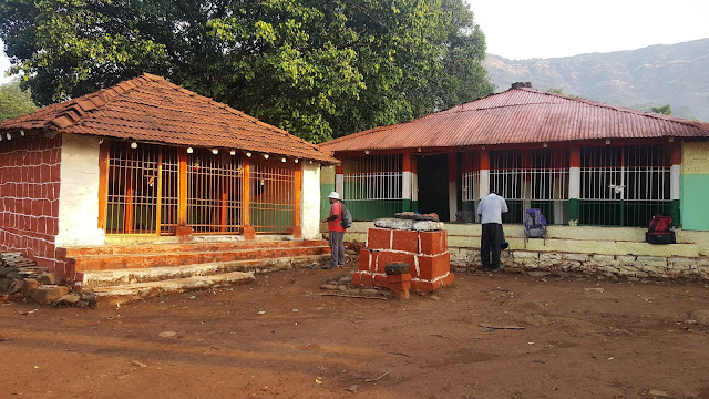
While it was not exactly raining the air was damp and monsoon clouds hovered on the horizon. We had nice hot Kande Pohe and piping hot tea at a local house. The admirable thing about most of the villagers/house owners we interact with or select as our base during our treks is that they are very polite & helpful, provide us with virtually unlimited food and tea and are very large hearted. We started our trek sharp at 8 am.The house owner also provided us with a guide for our trek.

 |
| Our gang before..enjoying the early morning hike..pic credit Kaustubh Palekar. |
We initially
were quite discouraged to see dense cloud cover all around, but as soon
as we reached the edge of the ghats, the weather cleared out and lo and
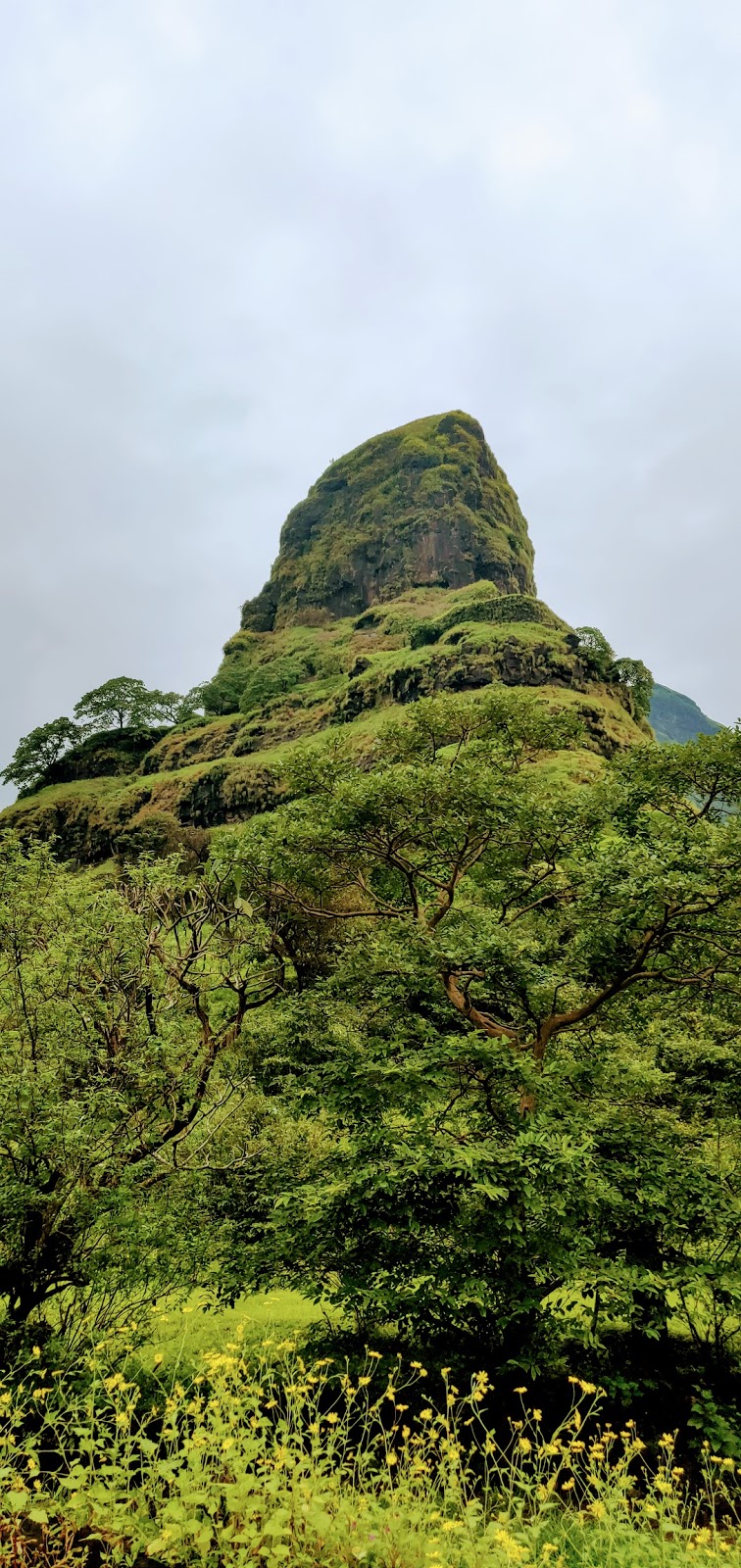
behold..we got our first glimpse of the awesome Kothaligad Fort jutting
out majestically from the konkan plains!
 |
| Dense fog and cloud cover welcomes us at start of Nakhinda Ghat..Pic credit Kaustubh Palekar |
The entire mood in the group became upbeat as the valley unfolded in front of our eyes..We quickly clicked as many snaps as we could before the clouds could come back..

We could see the entire route leading down to the Konkan Plains.The start of Nakhinda Ghat is more like a normal descent and the route passes through dense shrubs and forest on the way. However
we faced a strange problem here. Through out our descent we were
tormented by mosquito like insects. We had never encountered this issue
in so many treks before and thus were caught a bit off guard. The insects thus tore into us and bit us at
every exposed part of our body. Soon we shrugged of our complacence and
covered our selves properly especially around the face and neck area.
  |
| Nice forest cover on the way! |
The Nakhinda Ghat route has a steady descent and thus there was not much strain on the legs. No wonder that the villagers frequent this route and prefer this over the steeper and exposed Kaulyachi Dhar/ridge route. Also the route is more convenient for villagers going and coming towards Wandre. We met a couple of village families climbing up towards
Wandre from Peth chi Wadi.
 |
| Vinit while descending Nakhinda Ghat..pic credit Kaustubh Palekar |
While
descending we got some breath taking views of Kothaligad and the
Sahyadri main range. The route would often go through dense foliage and
then emerge on the face of the cliffs often taking us right on the edge
of the ghats during traverses.

The slopes were as always full of Karvi plants. We could hear the Green Barbet as well as other birds chirping in the dense canopy. Beautiful untouched patches of semi deciduous forests kept us company. After descending for about 2 hour & 15 mins we reached the lower plateau or machi, on which Peth chi wadi village is located. The village is another 30 to 45 mins walk from the lower plateau. We crossed the Peth aka Kothaligad fort from the northern end of the fort.
 |
| The Sahyadri Main range, Nakhinda on left side of the mountain, we started our descent from just below the windmills. |
 |
| Peth Fort from the Machi or lower plateau. |
 |
| Rice plantations at Peth chi Wadi. |
We reached Peth chi wadi exactly at 12 noon. We had started from Wandre at 8 am and thus had been continuously walking for 4 hours. We took a 15 minutes break at Pethchi wadi and quenched our thirst with some limbu pani and gulped down a litre of water as the humid air in konkan was now taking its toll.

The ascent to the fort begins just outside the village on the north west side of the fort. The route is moderately easy, though being monsoon some patches were quite slippery and one needs to be careful while negotiating the rocks as they are covered in moss. We reached the top of the fort in about 45 mins.The fort is basically divided into 2 parts. The lower part houses a Temple of Lord Bhairav and a large cave. The cave could be at least 1000 years old and has one more inner chamber/sanctum.The cave has strong rock pillars for support and intricate carvings on the pillars, walls and door frames. The door way to the inner chamber has Lord Ganesha idol on the entrance. Thus one can safely assume that the fort was much more than just a watch tower and must be an important center for conferencing/meditation/ learning in the past.
 |
| PC: Kaustubh Palekar |
 |
| P.C. Kaustubh Palekar |
Above the cave is the Upper/ higher part of the fort which is the top of the funnel like rock massif. There are circular steps carved from inside of the funnel like rock which lead to the top of the fort.
P.C: Kaustubh Palekar
 |
One cannot help but marvel at the Engineering and sculpting skills of our forefathers. Once on the top, one gets 360 degrees view of the ghats. On the north one can see the Padar Fort, Siddhagad and the Bhima Shankar plateau, and then all along the east one can see the magnificent Sahyadri main range. Tungi pinnacle is visible to the North West. There is a large water cistern on the eastern end .There is also a cannon on the northern face of the fort.

 |
| Kaulyachi Dhar or Ridge which we climbed on our way back to Wandre |
 |
| Amazing views while descending from Kothaligad top..!P.C : Kaustubh Palekar |
In 1684, Naro Trimbak, a brave Maratha warrior launched a gallant attempt to reconquer the fort but he could not succeed and gave his life for the same.( Reference: "Saad Sahyadrichi, Bhatkanti Killyanchi" by Prof. P.K.Ghanekar).
One has to be particularly careful while descending from the top especially during monsoon, as a small turn just before the steps enter the funnel is exposed. We quickly descended to the lower part of the funnel and reached Peth village at 2.30 pm. We had nice lunch at one of the village houses of Pithla and Bhakri and topped it by gorging on the aromatic locally grown variety of rice.
We started for our return journey at 3.30 pm sharp. One glance at the ridge (Kaulyachi Dhar) and Mukund Pate Sir remarked that we will cover this in 2 hours and be on top of the deccan plateay by 5.30 pm. And he was absolutely right. The entire group was now excited to climb this ridge which directly connected Kothaligad to the main range and all climbed it at a steady clip. The ridge while it looked straight forward from a distance proved to be challenging. There was complete exposure on either side and not much to hold except some bunch of grass and shrubs. Fortunately the sun was showing bright and hence the steeper inclines were less slippery. There were 2 rock patches, the 1st one had to be tackled from the right hand side and was moderately difficult as the ground underneath was slippery. One mistake and one would slide straight in the valley below. However Tushar Poman and other seniors ensured that they supported all the members and helped them to negotiate the difficult patch.
 |
| Negotiating the Kaulyachi Dhar ridge!!P.C: Kaustubh Palekar |
 |
| Kothaligad from Kaulyachi Dhar top..P.C: Kaustubh Palekar |
As predicted by Mukund we reached the top at exactly 5.30 pm. However Wandre was still a fair distance away. It was going to take another determined and a bit draining 2 more hours of walking before we would reach Wandre.
All along our guide, an old and seasoned villager had guided us with pin point accuracy. However in the last patch about 5 kms from Wandre he proposed to take us by a short cut which proved to be in fact a longer circuitous route. However the benefit of this route was that we got a closer glimpse of the famous "Wandre Khind" an important landmark on the Lonawala-Bhimashankar cross country trek. While the last patch of the trek was quite demanding, our tired-ness vanished as soon as we sipped on hot tea and bhel after reaching Wandre village.
It was an amazing day of trekking for us. We had walked about 25 kms in a single day and with aplomb!
This was my first Ghat route trek and special credit is due to our ever reliable and resourceful Mr.Vinit Date for bringing this all together with his customary perfection!!
Gratitude to Kaustubh for allowing me to share some super snaps!
Also i was fortunate to meet new friends and trek mates viz Mr. Kaustubh Palekar, Chinmay Kirtane, Shrihari Kulkarni , Dr Shrikant Mapari and his amazing daughter Ms Rucha Mapari ( Rucha studies in Std 12th and has recently successfully completed the Pune to Kanyakumari cycle rally of an astounding 1650 kms and also completed 1001 surya namaskars on reaching Kanyakumari on the eve of Vivekanand Jayanti along with other wonder kids from Jnanaprabhodini school!!).
Some important points to be noted:
1). Please ensure that you exercise regularly before you take up this or any other arduous trek.
2). Please do not litter and and carry all your waste back with you after the trek.
3). Stay close with the group and do not wander alone in the forest.
4). At all times carry at least 3 litres of water per day. Very important to stay hydrated.
5). Respect the guides you hire and make them a part of your trekking team, share your food with them and do not give your sacks to them to carry.
6). Try and gather information about the geography and historical importance of the places you visit.
7). Please respect the time given to your fellow trek mates and be on time always.
Jai Shri Ram..Really fantastic blog Amit. keep Writing.
ReplyDeleteThanks Mukund. Tumchya sarkhya Damdar mitran mule trek chi maja dvigunit hote!
DeleteYour commentary kept me captivated all throughout. Indeed, these routes need to be rediscovered. Yours was absolutely fascinating experience. Thanks for sharing with us.
ReplyDeleteThanks Shirish Dada!
DeleteSuperb Amit. The idea of covering a Ghat with its guarding fort itself is fascinating. Photos took me to the magical atmosphere....looking for more blogs.
ReplyDeleteThank you Sameer Dada.Would love to go together.This year for sure lets execute!
DeleteWell done Amit. U have a shown a talent for writing, well supported by photos by Palekar. More blogs r awaited about other treks.
ReplyDeleteThanks Shrikant Dada. 1 more coming soon. I am on core leave till 14th March and hence got some time to work on the pending blogs.
DeleteWell crafted...made me a part of the journey...mayur mulani
ReplyDeleteThanks bro..will plan some thing for our grp once the summers r over.
DeleteGood experience & info for new trekker's, hope to join you one day
ReplyDeleteThank you!
DeleteWow Amit !!! I loved reading your blog !!! Looking forward to join you on one of these.... Lynette
ReplyDeleteThanks Lynette.You are most welcome..
DeleteNice Amit , very good information and well written.
ReplyDeleteYou are creating good examples among young trekkers
BR// Nitin Erande
Thanks Nitin!!
Delete